Geographic Information Systems (GIS) are tools used in many fields of knowledge because of their usefulness in handling geographic information and associated data to perform analyses that allow for decision-making.
The Irrigation Sustainability Observatory uses GIS to manage large amounts of graphical information. This information generally derives from the work of the Ministry of Agriculture, other official bodies, and a combination of both. This allows for the study and analysis of various components and variables that directly or indirectly influence irrigation, as well as their monitoring, with the main objective of optimizing resource use and improving the productivity and sustainability of irrigation. To be successful, it is essential to ensure that the information is as up-to-date as possible, which requires complementary fieldwork and office work.
The following document contains the main technical concepts of these tools and practical applications from a general point of view and in irrigation in particular, which will help to contextualize the application of GIS.
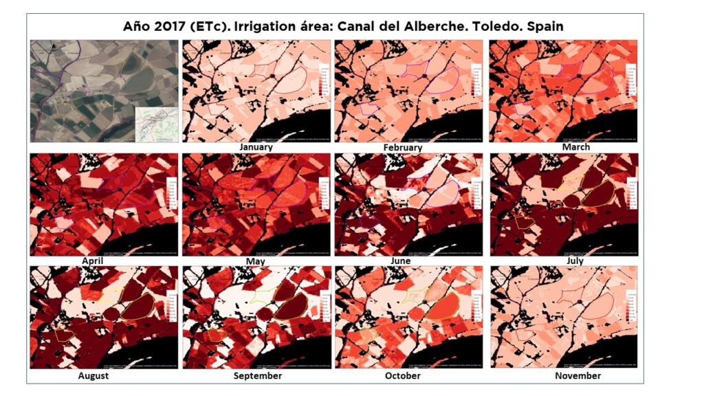
The term "remote sensing" is a translation of the English term "remote sensing," which was coined in the early 1960s to describe what could be described as "remote observation." Essentially, it consists of obtaining certain types of information about a surface by analyzing data acquired by sensors that are not in contact with that surface (at a distance). This data is derived from the interpretation of electromagnetic radiation reflected or emitted by the surface being studied and captured by the aforementioned sensors. In addition to data acquisition, remote sensing also includes data processing, which generates the information available to the end user.
This technique has many applications, and examples applied in agriculture include: mapping soil vegetation cover, identifying crop species, estimating crop water needs, soil moisture, crop water stress, soil characteristics, crop health, predicting crop yields, etc.
The Irrigation Sustainability Observatory makes use of this technique, either directly or indirectly through the use of information resulting from other studies that have used this technique.
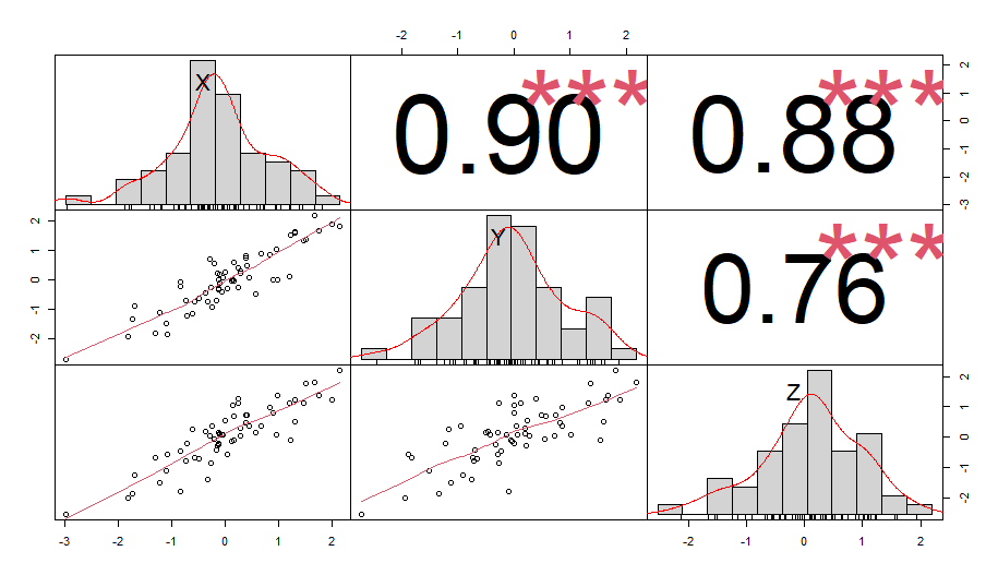
Statistics is a science that deals with the collection, organization, classification, representation, and analysis of data to obtain results that facilitate decision-making.
Currently, there are many applications of statistics in agriculture, such as the design of significant samples to collect relevant information to understand trends in a studied population, analysis of crop distribution, analysis of yields over time; in short, it helps to identify and understand the distribution of data for a variable as well as identify dependencies between different variables.
The Irrigation Sustainability Observatory also uses statistics to display data of interest related to irrigation and analyzes the relationships between different data groups.